LAST UPDATED – 4/2/26 – Corona Arch Trail Hiking Guide
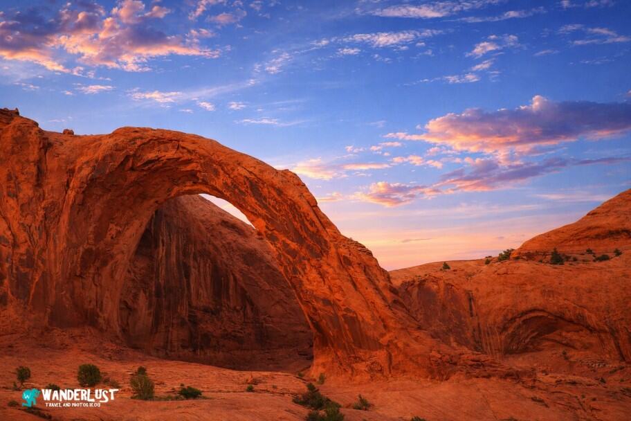
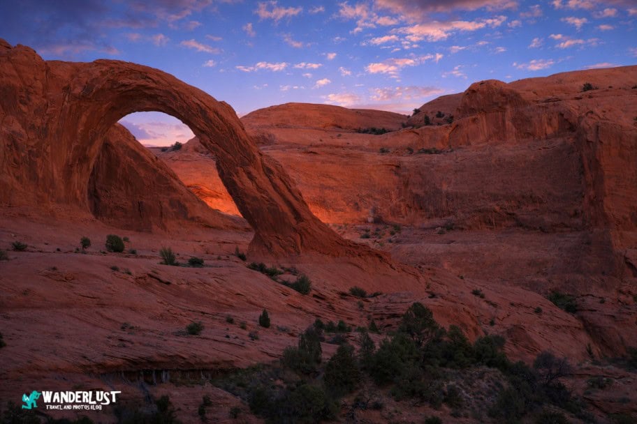
While Arches and Canyonlands draw most visitors to Moab, the Corona Arch hike remains one of the region’s true hidden gems. Close to town, easy to reach, and accessible for most hikers, it’s quickly becoming a local favorite—especially since the arch itself is every bit as big and beautiful as the famous Delicate Arch inside Arches National Park.
If you’d rather avoid the long lines and heavy crowds at Arches, the Corona Arch trail is an excellent alternative. You’ll still experience one of the area’s most impressive arches along with classic Southern Utah terrain, all without the national park congestion.

In this guide, I am going to give you all of the information you need to plan a successful trip. I cover the best times to visit and the best ways to get there so that you can maximize what you can see and do on your trip. In addition, I outline the top things to see and do while you are there, as well as the best places to stay and eat. With this information in hand, you can be confident that your trip to see the Corona Arch will be one that you remember for the rest of your life.
Corona Arch Hiking Guide Navigation Menu

How to Get to the Corona Arch

The Corona Arch Trail is located just outside of the city of Moab in Southern Utah. Widely considered to be the adventure capital of the American Southwest, one thing that the Moab area certainly is never in short supply of is adventure.
In addition to Arches and Canyonlands National Parks, which are two of the Southwest United States’ most popular parks, the Moab area also has thousands of miles of great mountain biking trails, a seemingly endless amount of backcountry to explore via ATV and 4WD vehicles, and some of the best and most beautiful hiking trails in the Southwest.
Drive Times to the Corona Arch Trailhead
| CityPark | Distance | Drive Time | Notes |
|---|---|---|---|
| Arches National Park | 15 miles | 0hrs 20min | World‑famous sandstone arches; Corona Arch sits just outside the park on BLM. |
| Moab, UT (CNY – Canyonlands Regional Airport) | 20 miles | 0hrs 25min | Closest airport to Corona Arch; small regional airport with limited commercial service. (Trailhead is ~20 minutes from |
| Dead Horse Point State Park | 30 miles | 0hrs 40min | Iconic overlook above the Colorado River. |
| Canyonlands National Park (Island in the Sky) | 35 miles | 0hrs 45min | Vast canyons, mesas, and overlooks near Moab. |
| Goblin Valley State Park | 100 miles | 1hr 45min | Hoodoo‑filled valley with unique rock formations. |
| Natural Bridges National Monument | 110 miles | 2hrs | Three massive natural bridges in a remote canyon. |
| Grand Junction, CO (GJT) | 115 miles | 2hrs | Regional airport with national connections; closest larger city outside Utah. |
| Goosenecks State Park | 125 miles | 2hrs 15min | Deep meanders of the San Juan River. |
| Glen Canyon National Recreation Area | 140 miles | 2hrs 30min | Lake Powell, slot canyons, and desert scenery. |
| Capitol Reef National Park | 145 miles | 2hrs 30min | Waterpocket Fold, orchards, domes, and canyons. |
| Mesa Verde National Park | 150 miles | 2hrs 45min | Cliff dwellings and cultural sites. |
| Monument Valley Navajo Tribal Park | 150 miles | 2hrs 45min | Iconic buttes and mesas on Navajo Nation land. |
| Salt Lake City, UT (SLC) | 235 miles | 4hrs | Major international hub; closest large‑airport city to Moab. |
| Denver, CO (DEN) | 350 miles | 5hrs 30min | Major global hub; long but straightforward drive via I‑70. |
| Las Vegas, NV (LAS) | 450 miles | 6hrs 30min | Large international airport; scenic desert drive. |
If you are looking to travel to Moab to do the Corona Arch Hike, the closest cities with major airports to fly into are Salt Lake City, Utah, and Las Vegas, Nevada. It is only a short drive from these cities to Moab, which you can use as your base of operations as you explore the Corona Arch and the other treasures of the Moab area.
In case you are curious as to how far Moab is from other cities in the American West, I have included a chart of driving distances above and a regional map below for you to review.
Corona Arch Location Map
Many people who visit Southern Utah will fly into Las Vegas and complete a loop trip through Southern Utah and Northern Arizona to see all of the area’s national parks, monuments, and wonderful points of interest.
In addition to the five national parks in Southern Utah and the Grand Canyon National Park in Northern Arizona, the trip will allow you to see such treasures as the Grand Staircase-Escalante National Monument, Glen Canyon National Recreational Area, the beautiful Antelope Canyon and Horseshoe Bend, the iconic Monument Valley, and of course, the Corona Arch hike.
If you are interested in exploring an itinerary through this area, starting and ending in Las Vegas, I have included a few itineraries I created for you to review below.
| READ MORE: | |
 |
|
| Ultimate American Southwest Road Trip | |
| READ MORE: | |
 |
|
| 7-Day American Southwest Adventure Itinerary | |
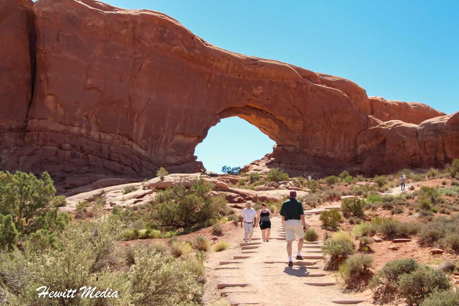
The Corona Arch Hike

The fact that the trail is so easy to find, is so easy for novice hikers to complete, and that the payoff waiting for hikers at the end is so monumental and beautiful are some of the things that make the Corona Arch hike such a popular one in the Moab area. In this section of the guide, I will give you all of the information that you will need to find the hike and complete it successfully.
Finding the Corona Arch Trailhead

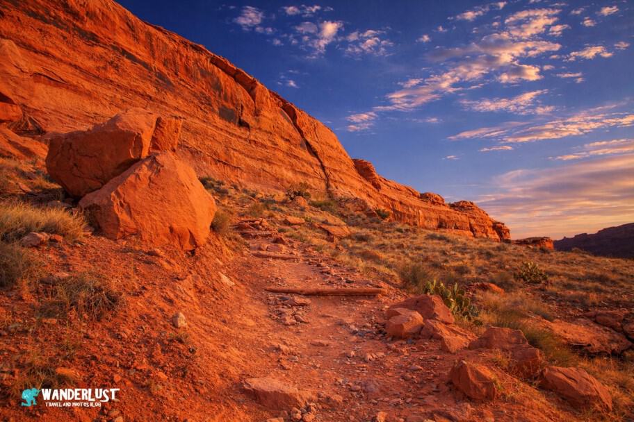
To reach the Corona Arch trailhead from Moab, head north on Highway 191. Just before the entrance to Arches National Park, turn left onto Highway 279. From there, follow Highway 279 as it winds along the Colorado River through the canyon for approximately 10 miles. The trailhead for the Corona Arch hike will be on the right side of the road.
This scenic stretch of Highway 279 is known for its towering rock cliffs—keep an eye out for climbers scaling the walls as you drive. A detailed map showing the route from Moab to the trailhead is included below.
Directions to the Corona Arch Trailhead from Moab Map
Corona Arch Trail Details

The Corona Arch hike is popular for good reason—it’s one of the most accessible and rewarding trails in the Moab area. The trailhead sits just minutes from town, and the 2.4‑mile out‑and‑back route gains only 459 feet of elevation, making it manageable for hikers of nearly all experience levels.
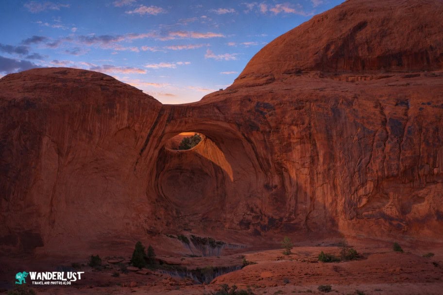
Although the trail includes a short ladder and a couple of wire‑rope sections, nothing feels overly technical. Most hikers, even those with limited experience or fitness, can comfortably make their way to the arch. Along the way, you’ll also spot Bowtie Arch, a striking pothole arch carved high into the sandstone wall, adding an unexpected bonus to the hike. To help you get a feel for the route, I’ve included a trail map below.
Corona Arch Trail Stats
| Trail Type: | Out-and-Back |
| Distance: | 2.4 miles/3.9 kilometers |
| Elevation Gain: | 459 feet/140 meters |
| Time to Complete: | 0.5 to 1.5 hours |
| Difficulty Level: | Moderate |
Corona Arch Trail Map
What to Bring to Hike to the Corona Arch

The Corona Arch hike isn’t the toughest trail in Moab, but it’s still one you need to respect. Summer temperatures can soar past 110 degrees, and wet sandstone can become slick enough to feel like ice. Heading out unprepared can put any hiker at risk. Below is a recommended gear list to help you stay safe and comfortable on the trail.
Hiking Boots
 |
One of the most important pieces of equipment that you will want to bring with you when you hike the Corona Arch Trail is a good pair of hiking boots. While the trail isn’t overly technical or difficult, there are sections of the trail where you will want to have good traction so that you don’t slip. If you are looking for a good pair of hiking boots to bring with you for the hike, I have included a link to some of my recommendations for you to review below. |
| View Recommended Options on Amazon.com | |
Hiking Shorts
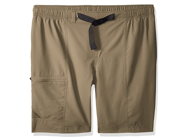 |
If you visit Moab during the spring, summer or autumn months, the chances are the weather will be quite warm. In the event that it is warm, you will want to make sure that you have a good pair of hiking shorts with you. For those of you who are looking for a good pair of hiking shorts for your trip, I have included a number of recommendations at the link below. |
| View Recommended Options on Amazon.com | |
Breathable T-Shirt
 |
In addition to having a good pair of hiking shorts, you will also want to have a good hiking T-Shirt with you for your hike of the Corona Arch Trail. My recommendation is to bring a breathable T-Shirt in order to wick moisture and keep you comfortable and cool. I have linked to a number of recommended breathable T-Shirts below in case you are looking to purchase one for your trip. |
| View Recommended Options on Amazon.com | |
Water Bottle or Water Bladder
 |
Arguably the most important piece of equipment that you will want to bring with you when you hike the Corona Arch Trail is a good water bottle or water bladder. In fact, having a reliable way to carry an adequate amount of water is probably the most essential piece of equipment that you will need to bring. For some recommendations on water bottles and bladders, please see the link below. |
| View Recommended Options on Amazon.com | |
Hiking Poles
 |
If you are a novice hiker, you might want to consider bringing a hiking pole or two with you when you hike the Corona Arch Trail. A good hiking pole or poles will help you keep your balance on the uneven rock surfaces. If you are looking for some good hiking poles, please see the link below for my recommendations. |
| View Recommended Options on Amazon.com | |
Wide Brimmed Hat
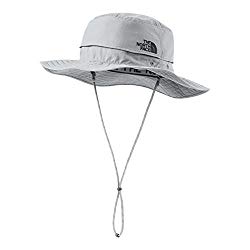 |
Southern Utah can be quite hot during the summer. If you are planning on hiking the Corona Arch Trail during the warm months of the year, having a wide brimmed hat with you is always a good idea. For some recommendations on good wide brimmed hats to bring, please see the recommendations at the link below. |
| View Recommended Options on Amazon.com | |
Sunglasses
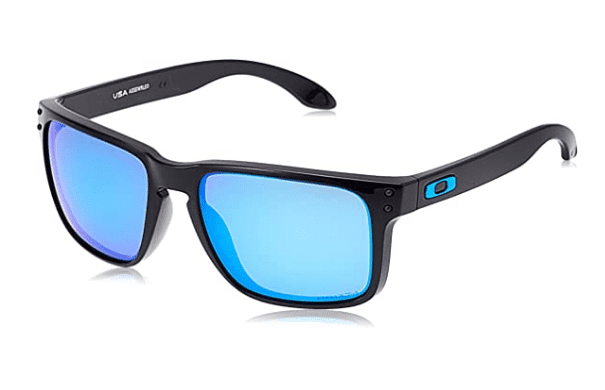 |
The sun can be pretty intense in the Southwest United States, so having a good pair of sunglasses with you when you hike the Corona Arch Trail is important. If you are in the market for a good pair of sunglasses, I have linked to some of my top recommendations below. |
| View Recommended Options on Amazon.com | |
Sunscreen
 |
Speaking of strong sun, you are definitely going to want to have some good sun screen with you when you hike the Corona Arch Trail. If you are looking for some recommendations on good sun screens, I have included my recommendations at the link below. |
| View Recommended Options on Amazon.com | |
Camera
 |
Finally, you are going to want to have a way to document the beauty that you see on this hike. Having a camera with you isn’t a necessity, but I definitely recommend it. I have a number of great cameras that I recommend if you are in the market for a new one, so take a moment to review the recommendations on my Amazon Store linked below. |
| View Recommended Options on Amazon.com | |
Best Times to Hike to the Corona Arch

Because Moab sits in the American Southwest, it’s easy to assume the weather stays hot year‑round. In reality, the area’s higher elevation creates much wider temperature swings than most visitors expect. If you’re planning a trip to see Corona Arch, take a moment to review the average temperatures and precipitation patterns I’ve outlined below—this will help you choose the best time of year for your visit.
Average Temperature (°F)
Because Moab sits at a higher elevation, its temperature swings are far more dramatic than in many other parts of North America. Summer highs can climb past 110 degrees Fahrenheit, while winter often brings snowstorms and icy, slick‑rock conditions. In my opinion, the best times to visit are late spring (April–May) and early autumn (September–October). Temperatures are much more comfortable, and you’ll avoid the heavy summer crowds.
Average Precipitation (Inches)
Moab doesn’t receive much rainfall, which is why it’s classified as a high desert. Even so, the little rain it does get can trigger dangerous flash floods in slot canyons and wash out backcountry roads. These conditions can make exploring the area—including the beautiful Corona Arch hike—more challenging. If you can, aim for a spring visit in April or May, which tend to be drier than the autumn months of September and October.
Other Things to See in the Moab, Utah Area

It may sound like hyperbole, but it honestly feels like it is impossible to overstate how amazing the Moab, Utah area is. In addition to being in very close proximity to three amazing national parks, the Grand Staircase-Escalante National Monument and all its treasures are also at the doorstep of the city.
If you are looking for some additional things to see in the Moab area after you have completed the Corona Arch hike, I have included links to some of the guides I have created for other area attractions for you to review below.
| READ MORE: | |
 |
|
| Arches National Park Visitor Guide |
| READ MORE: |
 |
| Canyonlands National Park Visitor Guide |
| READ MORE: |
 |
| Dead Horse Point State Park |
Where to Stay in Moab, Utah

Campgrounds
When visiting the national parks and monuments of the United States, it is a really neat experience to camp out during your visit. Some of the best campgrounds in America can be found inside the country’s national parks and monuments and the surrounding areas. If you are interested in camping out during your visit, I have included a map of some recommended campgrounds for you to review below.
Hotels
If camping is not your speed, you need not work as there are a variety of good hotels for you to choose from in the area as well. If you are in the process of planning your trip to Moab and are looking for recommendations on hotels in the area, I have included a map and list of recommended hotels and different price points for you to review below.


Other Corona Arch Hike Resources

When planning any trip, you can never have too many resources at your disposal. In addition to the information I have provided you in this guide, I have linked to several other resources below that have great information that you can use to plan your trip to see the Corona Arch.
- Utah.com – Corona and Bowtie Arch Hiking Trail
- VisitUtah.com – Corona Arch Trail Utah
- Alltrails.com – Corona and Bowtie Arch Trail
- Discover Moab – Corona Arch Hiking Trail
- TripAdvisor – Corona Arch
Activities and Tours in the Moab, Utah Area

In addition to all of the wonderful national parks and monuments to see in the Moab area, the area is also known for its many amazing adventure activities. In fact, it is widely regarded as the adventure capital of the American Southwest. If you are looking for a fun activity to fill out your itinerary during your stay in the Moab area, I have included a list of recommendations for you to review below.
Recommended Moab, Utah Off-Road Tours
Recommended Moab, Utah Sightseeing and Airplane Tours
Recommended Moab, Utah Rafting and Paddle Board Tours
Recommended Moab, Utah Canyoneering and Climbing Tours
Recommended Moab, Utah Bicycle Rental
Corona Arch Photo Gallery
I have been to the Moab area countless times during my many years of traveling, and I have taken some absolutely fantastic photographs while visiting the area. Many of these great photographs I have taken while doing the Corona Arch hike. If you would like to see some of the photographs I have taken on this hike, I have included a gallery for you to review below.
If you’re interested in exploring more of my travel photography, I’d love for you to join me on Instagram! Creating this blog to share my free guides, itineraries, and travel photography tips takes a lot of effort, and a follow on Instagram would truly mean the world to me. Your support makes it all worthwhile!
FOLLOW ME!


Don’t Forget to Subscribe to My Adventures!

Let Me Help You Save On Your Next Adventure!
‘Start Exploring Today’ Merchandise Available Now!
 |
 |
 |
 |
 |
 |
 |


Holy cow – your pictures are stunning! What a beautiful arch! Looks like you had the place to yourself. What day/time did you arrive?
Thank you!! I think the 116 degree heat scared all of the sane people away 😂
I went late afternoon during the week, but the heat was brutal. I saw one other person on the trail and they turned back halfway.
I was sane this time, but if you’ll remember, we went to Death Valley two years ago… in the middle of summer!! Few people are dumb enough to do that. 🙂
Now that would be HOT!! 🥵
Wow!!! It is beautiful there! I would love to visit here sometime!
It is amazing!! 😀👍
I didn’t know that Corona Arch existed! Thanks for sharing!
You are very welcome!! 😃
Great post! I’ve never heard of Corona Arch but would love to check it out.
It is such a beautiful arch. It’s sad because it is seeing more traffic recently and gotten some graffiti.
That’s terrible.
What a beautiful arch! Awesome pictures!
Thank you so much for the kind words!!
Great photos! We’re going to Moab next week to hike. We will definitely go to Corona Arch. Would you recommend early morning or late afternoon for photographing?
Hi Beth! Excellent! You will LOVE Moab! This time of year, I would definitely recommend early morning. The sun will rise behind Corona Arch from where you can view it (just to the right). The sun will set behind you, so you won’t be able to get as good of pictures in the evening. Have fun!!
Hi!
What a great suggestion for an alternative arch with a hike that sounds actually doable! I remember last time I was in Canyonlands NP getting a sunrise shot of the arch there. When I arrived, a literal bus load of Chinese visitors were climbing all over the arch and we had to ask them to step off for a moment to get the shot. Seeing a less visited arch would be great! Also it can’t be overstated how the heat can get you here in summer!!
Thank you so much for the thoughtful comment!! I know what you mean about Mesa Arch. It gets insanely busy. Too bad to hear about people climbing on it. You will LOVE Corona Arch!!